


Research helps us understand, appreciate, and connect with the landscapes that make this area unique.

A side-by-side stereograph shows the Roaring Fork Valley before the removal of the Ute people. Photo: William H. Jackson, Hayden Survey 1873.

A recreator relaxes at the Penny Hot Springs, one of the many geologic features that makes the Roaring Fork Valley unique.

Two people conduct a vegetation survey in the mountains.
Our Changing Watershed
Climate change is reshaping the ecology and hydrology of mountain watersheds like the Roaring Fork. The Roaring Fork Observation Network (also known as iRON) is a long-term research and outreach program managed by the Aspen Global Change Institute. The program’s goal is to help land managers, local residents, and scientific researchers better understand the relationship between warming air temperatures and shifts in the systems that support natural and human communities.
The Roaring Fork Observation Network collects and shares data on soil moisture, climate, and ecology in a Colorado River headwaters basin.
“The natural world is dynamic, not static, and the older each of us gets, the more apparent is this truth.
– John Magnuson, Long-Term Ecological Research and the Invisible Present
Learn more with the Guidebook to Soil Moisture in the Roaring Fork
See the GuidebookSoil Moisture Conditions in the Valley
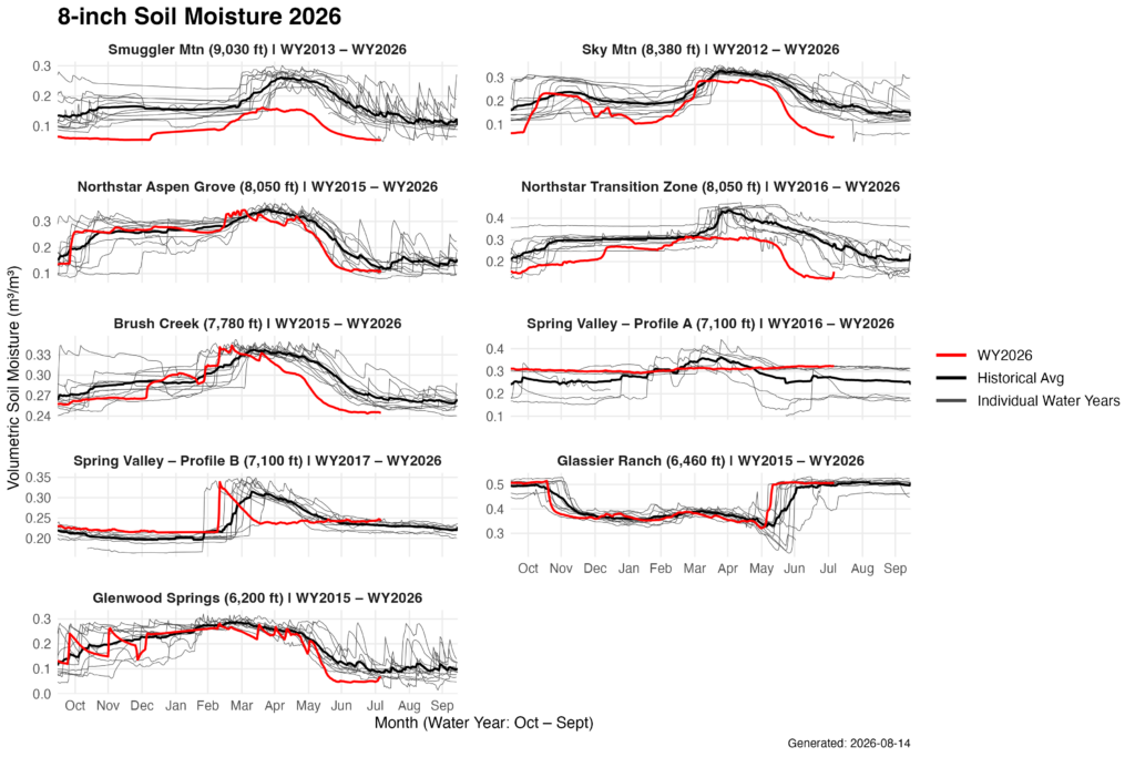
Soil Moisture at 8 Inches: Water Year 2026 in Context
Each panel above compares this water year’s soil moisture at 8 inches (red) against the station’s full record, the long-term average (black), and every individual year on file (gray). Stations are ordered by elevation, from Smuggler Mountain at 9,030 feet down to Glenwood Springs at 6,200 feet.
Two patterns stand out. First, the higher-elevation sites started the year dry and stayed dry: Smuggler Mountain tracked near the bottom of its record from October onward and never reached a normal spring peak. Second, and more widespread, dry-down came early and fell fast. At Brush Creek, Northstar Transition Zone, and Glenwood Springs, soil moisture held close to average through the spring recharge period but then dropped in May and June to among the lowest values on record for that date, several weeks ahead of the typical seasonal decline.
Glassier Ranch is the exception, tracking near average through summer, consistent with its lower-elevation, irrigated setting.
Soil moisture at a single depth and a single point doesn’t capture everything happening across a watershed, but the timing signal here is consistent across most of the network.
explore the network stations
The iRON program centers around data collected by 10 stations spread across the watershed’s elevational gradient and representing a variety of ecosystem types. Stations collect recurrent data on soil moisture and weather conditions.
Click on the station grid below to learn more about each station.


Roaring Fork Observation Network Data
Explore the data
The Roaring Fork Valley
The Roaring Fork Valley is a 1,451-square mile (3,769 square km) watershed located in the Rocky Mountains of Colorado. Our network stations represent the varied ecozones of this watershed, from the scrub oak dominated region near the confluence of the Roaring Fork and Colorado Rivers to the delicate high alpine habitat above 12,00ft (3,660m) on Independence Pass.

Over 30,000 people live in the Roaring Fork Watershed. As a headwater for the Colorado River, the basin provides water to an additional 40 million people out west as well as to residents of the Colorado Front Range who receive their water via transmountain diversions.
The economy of the Roaring Fork Watershed is largely recreation-driven today, but legacies remain of farming, ranching, and mining. With the population in the area projected to continue growing, relationships with the natural environment will continue to be redefined over time. Questions of development, water availability, wildlife conflict, and use of parks and trails must be considered from a dual perspective of local pressures and the context of climate change impacts. The iRON program provides a unique resource to help the Roaring Fork community understand the role of climate, hydrology, and ecology in sustaining the special qualities of this area.
Why Soil Moisture?

Soil moisture is a hidden but critical player in the interactions between the atmosphere, soil, streams, and plant life. It is critical in shaping ecosystems and helps determine which plants will survive and thrive in a given location. Soil moisture also acts as an intermediary in the exchange of water between the air, plants, and streamflow. Researching the dynamics of soil moisture processes can help researchers better model climate change impacts in mountain systems and can help resource managers better forecast future conditions, from water supply to the suitability of different plant species restoration efforts.
Changes in air temperature and timing or volume of snowmelt or rain all have consequences for soil moisture. As the climate of our valley warms, soil moisture patterns are likely to change too—but how those changes occur and their impacts across other systems will only be revealed if long-term observations record those shifts over time. The Roaring Fork Observation Network helps provide a valuable record of this kind, with benefits for both international researchers and our own local community.
Network Blog

AGCI releases guidebook on soil moisture data for the Roaring Fork Watershed
The Guidebook utilizes data from AGCI’s soil moisture monitoring network in the Roaring Fork Watershed to explore how and when soil moisture data can inform water supply planning.
Intern Reflection: Independence Pass, Research at 12,080 ft
AGCI-CW3E summer intern Fallon Santander ponders the question: can research be ceremony?
Intern Reflection: Shifting focus–my summer of unexpected setbacks and learning opportunities
After a weekend injury changed her summer field plans, intern Hannah Harbert shares her path to learning the importance of being able to pivot in a career in research.
Intern Showcase: Soil moisture across the landscape
This overview provides a summary of results from a project mapping soil moisture across a subset of the landscape for each site in the Roaring Fork Observation Network (iRON).
Partners
AGCI’s iRON monitoring network and website were created with support and funding from:
- Aspen Community Foundation
- Aspen Valley Land Trust
- Aspen Center for Environmental Studies
- City of Aspen
- City of Glenwood Springs
- Colorado Mountain College
- Colorado Natural Heritage Program
- Colorado River Water Conservation District
- Colorado Water Conservation Board
- Pitkin County Healthy Rivers and Streams
- Pitkin County Open Space and Trails
- Pitkin County Public Works